Mount Katahdin is more than just a mountain – it’s a journey through the ancient forces of geology, the delicate balance of ecology, and the deep cultural significance for the native Wabanaki people. Join me as I recount my thrilling hike to the summit, navigating the Knife Edge Trail, exploring the unique flora and fauna, and uncovering the sacred history of this revered peak. Whether you’re a science enthusiast, a cultural explorer, or simply seeking adventure, this trek offers something truly unforgettable.
1 Return to Katahdin: A Journey Through Memory, Science, and Spirit
It was a quiet Wednesday afternoon when the familiar call of adventure stirred something deep inside me. Almost twenty years had passed since I last set foot on the rugged slopes of Mount Katahdin, yet the memories of that ascent had stayed with me like an old friend. I had climbed the mountain three times before, but this time felt different. I wasn’t just returning for the hike—I was returning to rekindle a connection with the landscape, the science, and the cultural significance that surrounded this majestic peak.
The decision was spontaneous, as most of my adventures seem to be. With the weekend ahead of me, I immediately began preparations, knowing full well that the mountain had changed as much as I had over the years. Mount Katahdin, the highest point in Maine, was no ordinary hike; it was a sacred place for the native Wabanaki people, a geological wonder shaped by millions of years of natural forces, and an ecosystem so fragile, yet powerful in its presence.
2 Quick Facts about Mount Katahdin, Maine
- Location: Baxter State Park, Maine, USA
- Elevation: 5,269 feet (1,606 meters)
- Mountain Range: Appalachian Mountains
- Significance: Highest peak in Maine; northern terminus of the Appalachian Trail
- Name Origin: “Katahdin” means “The Greatest Mountain” in the Penobscot Native American language
- Best Time to Hike: Late June to early October (weather dependent)
- Popular Routes: Hunt Trail (Appalachian Trail), Knife Edge, Cathedral Trail
- Difficulty Level: Strenuous; not recommended for inexperienced hikers
- Notable Features: Knife Edge ridge, alpine tundra, glacial cirques, dramatic views
- Cultural Importance: Sacred mountain to the Penobscot Nation and significant in local folklore
- Park Rules: No dogs, limited access permits required, strict leave-no-trace policies enforced
- Park Entrance Fee: $16 USD per vehicle for non-residents; free for Maine residents
3 Planning and Preparation
Preparing for a return to Mount Katahdin was more than just packing a backpack. In those twenty years, Baxter State Park had implemented stricter regulations to preserve the environment, and with good reason. As I delved into my research, I discovered that the park now required parking permits for the limited spaces at the trailheads, which had to be reserved well in advance. Being August, the peak of hiking season, all permits were already taken. For a moment, I felt the possibility of my journey slipping through my fingers.
But then, like any seasoned adventurer, I crafted a backup plan. I would take my chances at the park gate, arriving long before dawn in the hopes that a few last-minute cancellations would allow me to claim a spot. The thrill of the unknown made my anticipation grow even stronger.
View this post on Instagram
By Friday afternoon, I arrived in Millinocket, the last outpost of civilization before entering the wilderness of Baxter State Park. The small town buzzed with hikers preparing for their own ascents, and I joined them in gathering supplies—four liters of water, a bottle of Gatorade, a large submarine sandwich, and an assortment of snacks. My hiking essentials had evolved over the years, but the excitement remained the same. And with a final touch of pragmatism, I reminded myself to bring cash for the park entrance fee. You don’t want to overlook that!

I set my alarm for an unearthly hour, knowing that the success of my adventure depended on it. By 4:30 a.m. on Saturday, I was in line at the park’s entrance, the headlights of cars casting long beams through the early morning mist. I wasn’t the only one with a dream of standing atop Katahdin’s summit, but I was determined. After what felt like an eternity of waiting, the ranger finally summoned me to come forward. I was one of the lucky few to snag a parking spot without a reservation.
With a grin that could only come from the anticipation of adventure, I pulled into the Roaring Brook Campground parking lot by 7:45 a.m. The trailhead lay before me, and I made a quick stop at the ranger station to register my planned route. The ranger, noticing my planned long loop over the Knife Edge Trail, kindly handed me a flashlight, just in case I was still on the mountain after dark. I thanked him and chuckled inwardly, knowing full well that this wasn’t just a hike—it was an experience that would stay with me long after I descended the mountain.
4 The Ascent: Geology and Ecology on the Knife Edge
The first steps on the Helon Taylor Trail brought a flood of memories—each footfall a reminder of past hikes, and yet, there was something new in the air, something different. The trail starts modestly, winding its way through thick forests, the morning light filtering through the trees in dappled patterns on the ground. I felt the coolness of the morning dew cling to my skin as I hiked upward along Roaring Brook, my senses heightened by the sounds of rustling leaves and the distant song of birds.
But it didn’t take long before the trail began to steepen, the familiar burn in my legs kicking in. It was a steep, continuous climb, and as I rose higher, the trees thinned, giving way to rocky outcrops that signaled the transition from forest to alpine terrain. It was then that the vastness of the park began to reveal itself, the thick green forests sprawling out in every direction, broken by the glistening blue lakes scattered like jewels across the landscape.
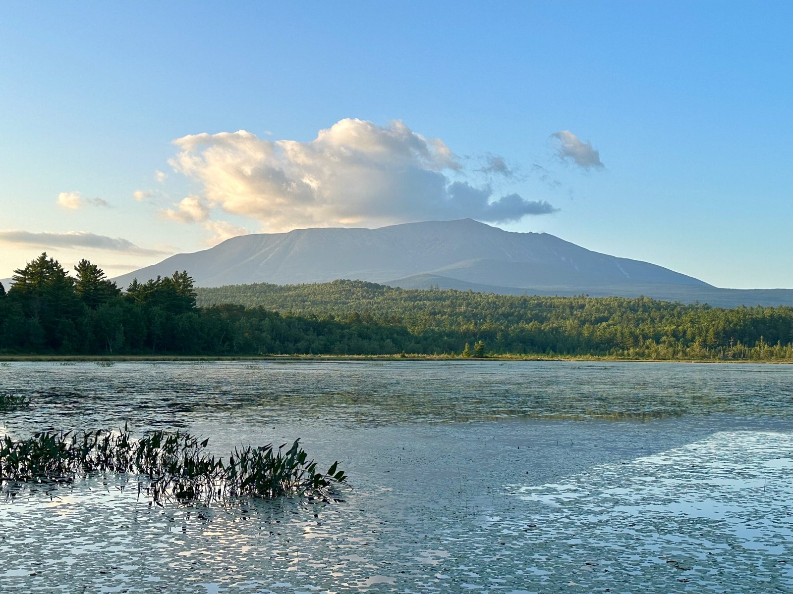
By mid-morning, I reached the treeline, and the panoramic views took my breath away. Below, Baxter State Park stretched endlessly, with its lakes, streams, and rolling forested hills. Above, the summit loomed, its jagged ridges beckoning me onward. But it wasn’t just the views that captured my attention. As I continued upward, the geology of the mountain began to reveal itself, telling the story of forces far older than the mountain itself. More than 400 million years ago, during the Devonian period, tectonic plates shifted with unimaginable force as the ancient continent of Laurentia collided with Gondwana, part of a process known as the Acadian orogeny. This powerful collision gave birth to the Appalachian Mountain range, including Mount Katahdin, as massive sections of the Earth’s crust were pushed upward.
The granite under my sneakers, so solid and immovable, was formed deep within the Earth’s crust as molten rock, or magma, which cooled and crystallized over millions of years. As these tectonic plates continued to shift and fold, this granite was exposed and lifted toward the surface. Over the eons, erosion from wind, rain, and glaciation shaped the landscape, leaving behind the rugged, jagged peaks and smooth talus slopes. The last major glaciation, around 20,000 years ago, carved out the valleys and cliffs, leaving Katahdin with the dramatic features we see today.
Walking along these ancient rock formations, it’s awe-inspiring to think about how these processes, set in motion hundreds of millions of years ago, still define the landscape. The forces of plate tectonics, once responsible for the rise of towering mountains, now continue their slow, imperceptible dance far beneath the surface, while the remnants of those actions are visible in every rock and ridge on Katahdin.
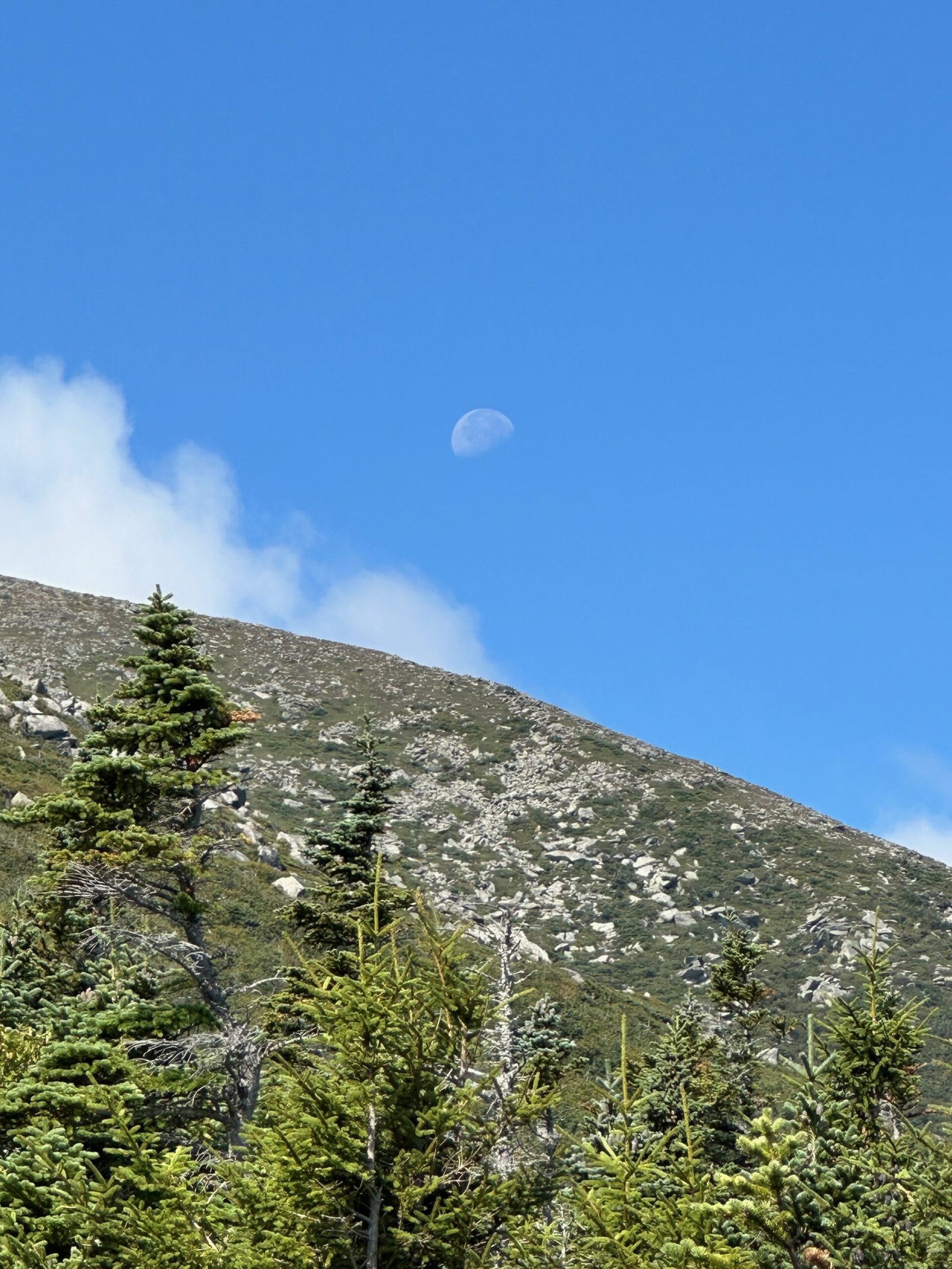
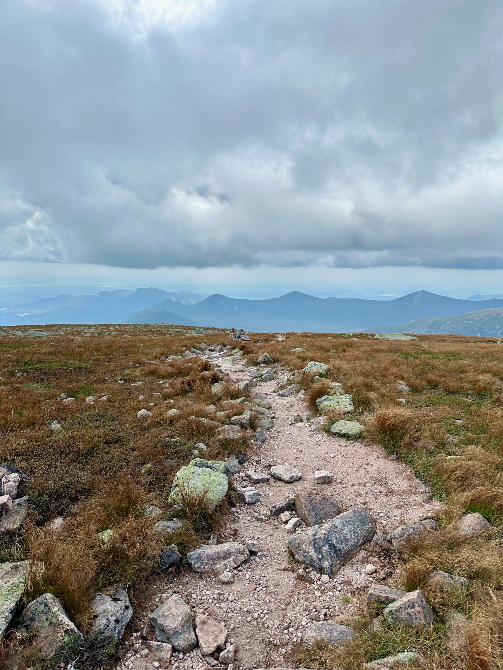
But geology was only part of the story. As I climbed, the alpine zone revealed an ecosystem that was as delicate as it was beautiful. Here, in the high-altitude environment, the vegetation is sparse, adapted to the harsh conditions of wind, cold, and thin soil. Tiny alpine plants clung to the cracks between rocks, their bright green and purple colors standing out against the pale granite. These plants, though small, were vital members of this fragile ecosystem, surviving in a place where few others could. The park stewards had left markers along the trail, reminding hikers to tread lightly, to stay on the path, and to avoid damaging these precious species. It was a stark reminder that while we might conquer the mountain in our own small way, we are but visitors in a world much older and more delicate than our own.

As I ascended toward Pamola Peak, the trail became steeper, the terrain more rugged. By noon, I stood atop the peak, my eyes scanning the jagged horizon ahead. In the distance, the Knife Edge stretched out before me, a narrow ridge of granite connecting Pamola to the summit of Mount Katahdin. The wind tugged at my clothes, and I took a deep breath. This would be the most challenging part of the journey—the Knife Edge Trail, infamous for its dizzying drops on either side, where one wrong step could mean disaster.
The sun was high in the sky as I began the precarious traverse. The rock underfoot was worn smooth in places, weathered by the relentless forces of wind and ice. I moved carefully, sometimes using my hands to steady myself on the rock. The trail was narrow, often just a few feet wide, with nothing but sky and distant valleys on either side. It was both exhilarating and terrifying, the kind of thrill that makes you feel alive in the deepest sense. Here, on the edge of the world, I felt a deep connection not only to the landscape around me but to the ancient history of the Earth itself.
Each step brought new views, new challenges. The rock formations around me were a study in geological history, shaped by the glaciers that once covered this land, and now left behind as silent witnesses to a time long gone. And yet, there was life here. Despite the harsh conditions, small clusters of alpine plants clung to the rock, resilient and tenacious. They were a reminder that even in the most extreme environments, life finds a way to thrive.

After hours of careful maneuvering, I finally reached the summit of Mount Katahdin. The sense of accomplishment washed over me as I stood at 1,610 metres (5,267 feet), the highest point in Maine. I took a deep breath, filling my lungs with the crisp, cool air, and looked out over the landscape below. It was a sight I would never tire of. The view stretched for miles—endless forests, shimmering lakes, and the undulating ridges of the Appalachian Mountains. In that moment, the exhaustion of the climb melted away, replaced by a profound sense of peace. The mountain had challenged me, but it had also rewarded me with a view that few people are fortunate enough to witness.
As I stood there, I reflected on how Mount Katahdin isn’t just any mountain—it’s the northern terminus of the Appalachian Trail, one of the most famous long-distance hiking trails in the world. The Appalachian Trail stretches for about 3,540 km (2,200 miles) from Georgia to Maine, passing through 14 states and countless ecosystems. For thru-hikers, reaching Katahdin’s summit is the final, triumphant moment of a journey that can take months. To stand here at the end—or beginning—of such a remarkable path is humbling, and it adds a profound sense of connection to the history and endurance of those who’ve hiked before.
I spent a quiet moment at the summit, eating the remainder of my sandwich and letting the enormity of the journey sink in. This mountain, with its ancient rocks and fragile ecosystems, had given me more than just a physical challenge—it had reminded me of the incredible beauty and power of nature, and of my responsibility to protect it. After a few photos and a long, satisfying gaze out over the vast wilderness, I knew it was time to begin the descent.

5 Descent and Reflection: From the Saddle Trail to Sacred Landscapes
With one last look at the summit, I began the long descent down the Saddle Trail. As is often the case with mountains, the hike down presented its own unique challenges, though not nearly as precarious as the Knife Edge. The steep trail forced me to focus, each step a careful negotiation with gravity, as the granite beneath my feet gave way to loose rocks and gravel. But despite the physical demands, I felt lighter somehow, buoyed by the sense of accomplishment that comes from standing atop a mountain like Katahdin.
As I descended, the rugged alpine landscape slowly transformed. The rocky, barren terrain of the summit gradually gave way to a softer, greener world, where small streams trickled over rocks and patches of grass sprouted between the stones. The vegetation became more abundant, though still delicate and sensitive to the elements. The stewards of the park had left signs along the way, urging hikers to stay on the marked trail, to protect the fragile alpine ecosystem from unnecessary damage.
The changing landscape was more than just a visual shift; it was a journey through time. The higher elevations of Katahdin exist in a different climate, a place where the air is thinner and colder, where the plants and animals must adapt to harsher conditions. But as I made my way down, the air warmed, the wind softened, and the trees reappeared, first as small, twisted shrubs and then as full-grown conifers that towered over the path.
One of the most remarkable things about Katahdin is how quickly the weather can change. The meteorological forces at play on this mountain are a reminder of nature’s unpredictability. Katahdin’s elevation, combined with its proximity to the Atlantic Ocean, means that weather systems can shift rapidly, and hikers often find themselves facing a completely different climate by the time they reach the summit. On this day, I was fortunate—the skies were clear, the wind light, but I had learned long ago to never take such good fortune for granted.
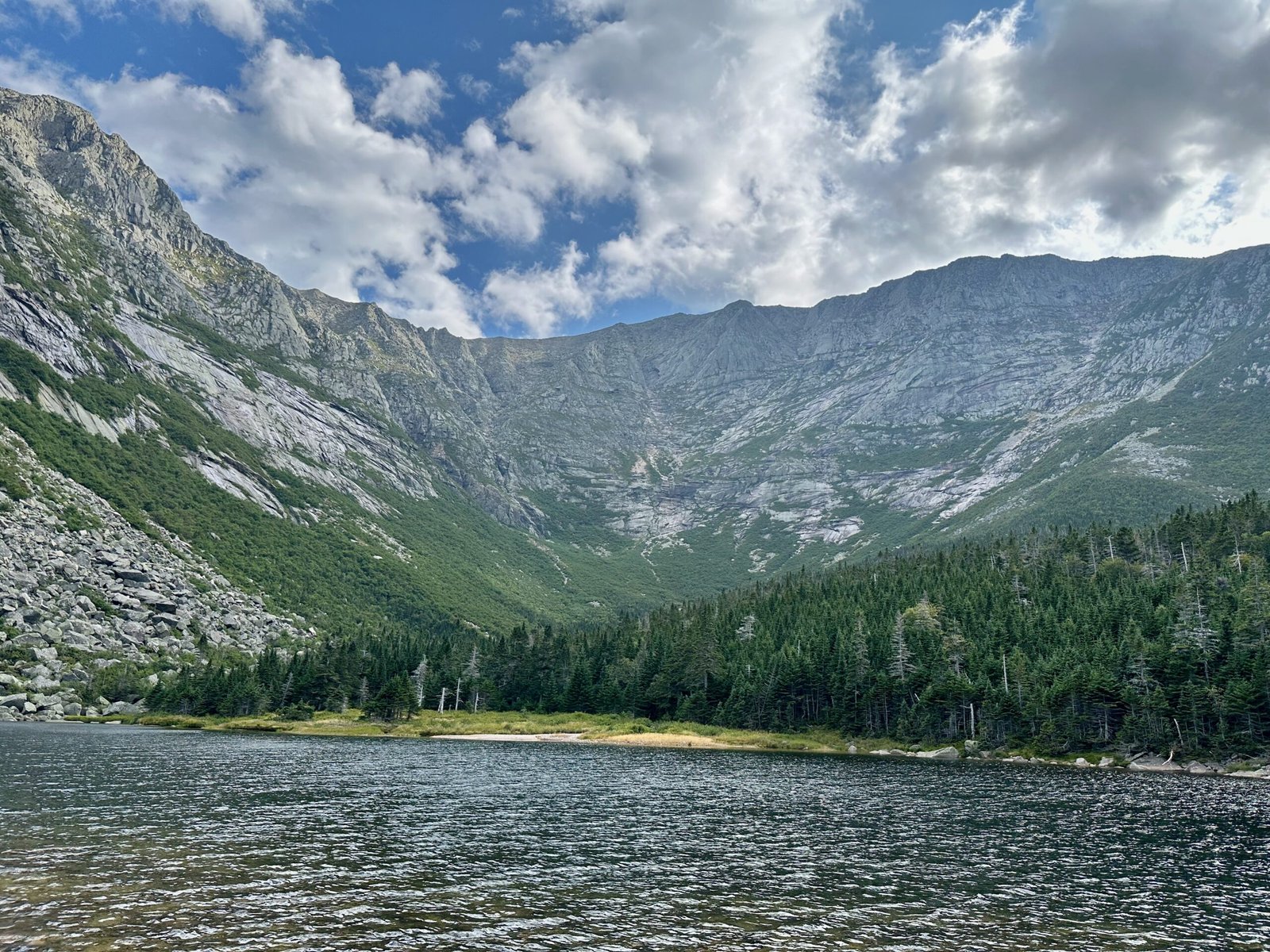
By late afternoon, I reached Chimney Pond, where a ranger station sits nestled beside the serene waters of the pond. Here, in the shadow of Katahdin’s towering peaks, I paused for a much-needed rest. The view from Chimney Pond was, in its own way, just as breathtaking as the one from the summit. Looking up, I could trace the path I had taken, from Pamola Peak to the Knife Edge, all the way to the summit, and down the Saddle Trail. The mountain loomed large, its granite face reflected in the still waters of the pond.
This place felt sacred—something more than just the result of geological processes or meteorological forces. There was a quiet power here, a presence that seemed to transcend the physical world. And indeed, for the Wabanaki people, Katahdin is more than just a mountain; it is a sacred space, a place where the spirit world and the physical world meet. The Wabanaki name for Katahdin means “The Greatest Mountain,” and for centuries, they have revered it as a place of deep spiritual significance. As I sat by the shore of Chimney Pond, I couldn’t help but feel a connection to that ancient reverence. There was something about this place that called to the soul.
”As I sat by the shore of Chimney Pond, looking up at the towering peaks, I realized that Katahdin wasn’t just a mountain—it was a place where the past and present converged, where the land holds stories far older than I could imagine.”
After a quiet moment of reflection, I began the final leg of my journey. The trail from Chimney Pond back to Roaring Brook was long but relatively level compared to the steep climbs of the morning. As I walked, I passed lakes and streams, their waters glistening in the late afternoon sun. The sound of running water filled the air, a soothing, constant melody that accompanied me through the forest.
I felt a deep sense of peace as I neared the end of the trail, a peace that comes from being immersed in nature, from the challenge of the climb, and from the knowledge that I had witnessed something truly special. This mountain, with all its rugged beauty and ancient history, had given me more than just a hike—it had given me a glimpse into the heart of the natural world.
When I finally arrived back at the Roaring Brook ranger station, it was 6 p.m., and the sun was beginning to set. I logged out with the rangers, grateful for the flashlight I hadn’t needed after all, and sat down on a nearby bench to reflect on the day. It had taken me over ten hours and about 16 km (10 miles) to complete the hike, and though my body was tired, my spirit was light.
I thought about the future—how many more times I would climb this mountain, and whether my legs would carry me to the summit again in another twenty years. But for now, I was content. I had reconnected with the mountain, with nature, and with something deeper. And as I drove away from the park, the sun sinking below the horizon, I smiled at the thought of returning once more, to stand at the summit of Katahdin, where the earth meets the sky.
6 Practical Travel Tips for Hiking Mount Katahdin
Hiking Mount Katahdin is not an adventure to be taken lightly, but with proper preparation, it can be one of the most rewarding experiences. My fourth ascent was a reminder that while the mountain’s allure is timeless, the logistics have changed over the years.
- When to Visit: Summer and early fall are prime seasons for hiking Katahdin. August, though crowded, offers the best chance of clear weather. But be prepared for sudden changes—Katahdin’s elevation means unpredictable conditions, even in the height of summer. Start your hike early in the day to avoid afternoon thunderstorms, which are common in the mountains.
- Permits and Reservations: Unlike my hikes two decades ago, today you’ll need a parking permit to access the trailheads. Baxter State Park limits the number of hikers to preserve the environment, and permits for popular lots like Roaring Brook fill up months in advance. If you don’t have a reservation, get to the park gate early—around 4:30 a.m.—to snag one of the few first-come, first-served spots. The park entrance fee is $15 USD for non-Maine residents, so be sure to bring cash.
- What to Pack: The essentials for Katahdin include a good pair of hiking shoes, plenty of water (I brought 4 liters), a few high-energy snacks, and layers of clothing. The summit can be windy and cold, even in summer, so a windbreaker or fleece is crucial. A flashlight is also a must—trail rangers may offer you one, but always be prepared in case your descent runs long.
- Trail Choices: The Knife Edge Trail is not for the faint-hearted. According to the park ranger, it’s generally better to ascend to the summit via the Knife Edge Trail, as descending the steep and narrow ridges can be more treacherous. If you’re looking for something less intense, the Saddle Trail offers a more gradual ascent. But for those seeking adventure, the Helon Taylor Trail leading to Knife Edge is both challenging and rewarding. Just make sure you’re physically prepared for the rugged terrain and sharp drop-offs on either side of the trail.
- Safety: Always register your route with the park rangers at Roaring Brook or Chimney Pond. The mountain’s rugged terrain can be dangerous, especially in poor weather. In the alpine zone, staying on marked trails is crucial, both for your safety and to protect the delicate ecosystems that call Katahdin’s summit home.
7 Pro Tips for Science Traveler
For the science traveler and cultural explorer, Mount Katahdin is a treasure trove waiting to be discovered.
- Geological Wonders: Bring along a field guide or use a geology app to identify the various rock formations as you climb. Katahdin is primarily composed of granite, formed from ancient volcanic activity. The smooth talus slopes you’ll see are evidence of glaciers that once carved their way through this region. At the summit, imagine the forces that shaped this mountain over millions of years.
- Alpine Ecosystems: Keep an eye out for Katahdin’s unique alpine plants, some of which are only found in this region. These hardy species survive in the harsh, high-altitude environment, and many are incredibly sensitive to foot traffic. By staying on the trail, you help protect these fragile ecosystems. I found the patches of bright green moss and tiny purple flowers to be an unexpected highlight of the hike—small reminders of life’s resilience.
- Cultural Significance: To truly appreciate Katahdin, take the time to learn about the Wabanaki people and their spiritual connection to the mountain. Katahdin is considered a sacred place, a meeting point between the human and spirit worlds. If you have the chance, visit a local cultural center or read up on the legends and myths associated with the mountain before your hike. Understanding this history adds a profound layer to the experience.
- Stargazing and Weather Patterns: If you’re lucky enough to spend a night at one of the campgrounds, don’t miss the opportunity for stargazing. Baxter State Park has some of the darkest skies in the region, perfect for spotting constellations or catching a glimpse of the Milky Way. The mountain’s unique weather patterns also make it a fascinating place for amateur meteorologists—bring a small barometer or weather-tracking app to monitor changes in pressure and temperature as you ascend.
- Photography Tips: For the best photographs, plan to reach Chimney Pond or the summit just as the sun rises or sets. The golden hour light casts a stunning glow on the granite ridges, and the reflections in Chimney Pond make for a perfect natural mirror. The views from Knife Edge also offer a once-in-a-lifetime shot, though you’ll want to take great care if photographing along the narrow ridge.
8 Explore More Northeast Adventures
If you found this Mount Katahdin adventure inspiring, you might also enjoy: